


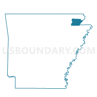
Hurricane Voting District, Greene County, Arkansas
About
Outline

Summary
| Unique Area Identifier | 526586 |
| Name | Hurricane Voting District |
| County | Greene County |
| State | Arkansas |
| Area (square miles) | 14.05 |
| Land Area (square miles) | 14.01 |
| Water Area (square miles) | 0.04 |
| % of Land Area | 99.71 |
| % of Water Area | 0.29 |
| Latitude of the Internal Point | 36.19604510 |
| Longtitude of the Internal Point | -90.42890060 |
Maps


Graphs
Select a template below for downloading or customizing gragh for Hurricane Voting District, Greene County, Arkansas


Neighbors
Neighoring Voting District (by Name) Neighboring Voting District on the Map
- Breckenridge Voting District, Greene County, AR
- Friendship Voting District, Greene County, AR
- Hopewell Voting District, Greene County, AR
- Marmaduke/Hurricane Voting District, Greene County, AR
- Reynolds Voting District, Greene County, AR
- Union Voting District, Greene County, AR
Top 10 Neighboring County Subdivision (by Population) Neighboring County Subdivision on the Map
- Union township, Greene County, AR (2,587)
- Hurricane township, Greene County, AR (1,685)
- Breckenridge township, Greene County, AR (1,319)
- Friendship township, Greene County, AR (822)
- Hopewell township, Greene County, AR (328)
- Reynolds township, Greene County, AR (98)